The Great Famine Double Ditch that Thurles Elected Councillors say does not exist.
The following email from Cllr. Mr Jim Ryan was sent to me in the last few days. Same now confirms that, sadly, the Great Famine “Double Ditch” is to be destroyed, to construct an inner relief road to benefit the new Thurles Town centre, being developed at Slievenamon Road. [The former town centre at Liberty Square, Thurles, having been destroyed by Tipperary Co. Council assisted by Thurles Municipal District Councillors].
TheEmail from Cllr. Mr Jim Ryan, Mill Road, Thurles, sent on March 1st, 12:21pm, is show hereunder.
Dear George In a follow up to your concerns regarding the removal or closure of the double ditch walkway in Thurles I can now confirm the following as presented to me by Roads Section of Tipperary County Council.
The proposed new Thurles Link road from Clongour to the Mill Road will be going through a small section of the double ditch or College Lane walkway on the Mill Road side.
The walkway will remain fully accessible with a newly opened access point from the new link road on the Mill Road side after construction.
The construction of the new Link Road will require the removal of the existing walled entrance on the Mill Road side along with the removal of a small section of the walkway itself on that same side.
The council stated that a full and comprehensive Archeology (Read as Archaeology)and Envirnomental (Read as Environmental) Assessment was carried out as part of the process that highlighted no concerns to the council or An Bord Pleanala
The Double Ditch or College Lane walkway will not be closed off to the public or removed once the construction of the new link road is completed. It will however be reduced slightly in length with a new access point on the Mill Road side.
I hope this clarifies some of the issues raised by you. Yours, Cllr Jim Ryan Comhairle Contae Thiobraid Árann Tipperary County Council.
The content shown in the above email, to say the very least, is a watered-down version, designed to affect my silence.
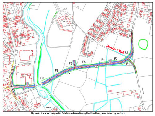
One example of this is that Mr Ryan has failed to notice that a further two-lane exit through the double ditch is designed to allow traffic onto the new road, from the new housing estate; see area/map reference indicated between F4 & F3. A second exit is designed possibly to connect to the rear of the Mary Immaculate College (formerly St. Patrick’s College). See between F6 & F5 on the map immediately published hereunder. Also on the map hereunder the Double Ditch has been shortened, by almost one half, compared to the cover map on our first video shown above. Same map referred to above is the first map ever recorded of this area in the 1800’s. This is deceit of the first order, by Council officials.
We now learn that none of our Municipal District Councillors can be trusted following the disclosure by Cllr. Ryan.
Tonight, I have replied to Cllr. Jim Ryan, Member of Thurles Municipal District, Council.
Sir,
Thank you for your communication of the 1st instant. My sincere apologies for failing to respond to your communication earlier.
I am fully aware, since June 3rd, 2019, that it was the intention of Tipperary Co. Council to demolish the Great Famine Double Ditch, latter situated within 500 meters of your principal private residence on the Mill Road, Thurles, Co. Tipperary.
It was to that end, indeed, that I contacted, in November 2019, Ms Rosin O’Grady, (Latter Tipperary Heritage Officer and Creative Ireland Co-ordinator), asking that she contact the National Monument Service, with a view to granting protection to this historic area. I was soon to realise that Ms O’Grady, despite her official title, is not fully independent of her titled duties, governed indeed by Thurles Municipal District Councillors and senior officials within Tipperary Co. Council.
Suffice is to state that Ms Rosin O’Grady has been instructed not to enter into further communication with me or has failed in her required duty as a County Heritage Officer.
You and your Council colleagues and Co. Council officials, including Chief Executive Mr Joseph MacGrath were informed regarding this wanton destruction of our local Thurles history, on May 24th 2020 (almost 10 months ago).
You Sir, including your County Council C.E. Mr Joe MacGrath, together with all elected Thurles Municipal District Councillors, and the Lowry Team, deliberately and with ill will, chose to ignore every communication sent to each and every one of them, while failing to acknowledge or even reply to any and all of my communications.
Following my complaint to the Standards in Public Office Commission(SIPO) regarding you and others of your Council colleagues, including TD’s Mr Jackie Cahill and Mr Michael Lowry; you were contacted by Registrar, Mr David Coleman, (Administrative officer, Corporate Services) regarding your failure to maintain proper standards of integrity; conduct, and concern for the public interest. It took you Cllr. Ryan, almost 3 years to inform me of what you knew, refusing to confirm the information which I had already informed you.
You will now please answer for the moment the following two questions:-
(1) Do you support this decision to remove yet another piece of Thurles history, which if properly marketed would benefit, greatly, the community of Thurles.
Note: I am aware that you are a senior, active committee member, with that grouping known as “The International Garden of Remembrance Committee”, (Chairman Mr John Worth), situated at St. Mary’s Graveyard, Church Lane, Thurles. You annually attend a ceremony in this garden to commemorate “An Gorta Mór – Ireland’s Great Hunger 1845-1849”. Indeed your group unveiled a large headstone of black marble, (latter which in the past I have strongly objected to its introduction, without planning permission), breaching, as it does, government heritage guidelines and regulations. Are you now going to support the destruction of a real piece of Thurles heritage, which Thurles can use to attract the ever elusive Thurles tourist?
(2) Do you or any other extended member of your family, either in the past or at any time in the future, expect to benefit, through the sale of land, or other advantage, conveniences or possessory rights, which is being now brought to bear, thus aiding the future destruction of the 175 year old Great Famine Double Ditch, at Mill Road, Thurles, Co. Tipperary.
Mr Ryan, you, your council colleagues, local TD’s and Co. Council Officials bring shame on this community and you are observed as no better than delinquent, vandals.
Your answers are of particular interest to me, in relation to steps I intend to take to reverse this outrageous, wilful and destructive decision.
Yours faithfully, George Willoughby.
I now invite Thurles Chamber of Commerce, Tipperary Tourism, Thurles Tourism groups and the Irish Government, to support the retention of this piece of valuable history. As a right-of-way Tipperary County Council are obliged to clean up this area and restore, that which they damaged on the watch of Mr Joe MacGrath, CE. Tipperary, Co. Council, in the last 9 years since 2013.
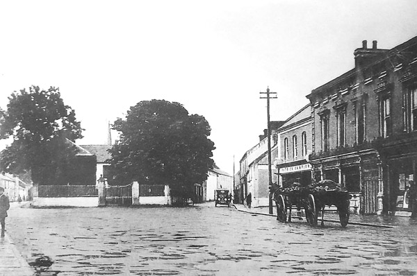
Cathedral Street, east of Thurles town centre, in Co. Tipperary has possibly undergone the most change in the last 50 years.
Gone of course is Ryan’s brewery stores, positioned in the monochrome picture hereunder, dividing Church Lane from Kickham Street (The Pike). Same has been replaced by modern shop units and a petrol station.
Image of Cathedral Street, Thurles (formerly known as East Main Street), possibly captured sometime between 1930 and 1940 based on the 1927 Ford Model T. Some 15 million of these cars were sold, and the model, as of 2012, stood eighth on the top-ten list of most sold cars of all time.
It was to this building, according to a traditional story, that a servant was dispatched from the Palace of Archbishop Price, in Cashel, Co Tipperary. Estate manager and the father of renowned Arthur Guinness, namely Richard Guinness, was in charge of supervising the brewing of beer for the estate’s employees on the Archbishop Price estate. Supplying beer to employees at that time was considered part of their weekly entitlement.
The servant had been charged with purchasing and delivering the necessary beer making materials, from Ryan’s brewery stores in Cathedral Street.
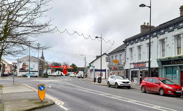
Cathedral Street, Thurles, February 2021. Photo: G.Willoughby.
Later, back in Cashel in the Palace kitchen, the purchased barley was accidentally roasted until virtually black, thus giving that unique burnt flavour known to us today as “Porters Ale” or “Guinness Porter” and described by the then Protestant Archbishop at that time as being “a brew of a very palatable nature.”
Our numerous readers of Thurles.Info all currently living overseas, especially those involved in searching for their “Roots”, are asked to please take special note.
Website www.irishgenealogy.ie, for free, has added a whole additional year of historic Births, Marriages and Deaths, now available to research.
The records now available online include: Birth register records – 1864 to 1920. Marriage register records – 1845 to 1945. Death register records – 1871 to 1970.
NB: Civil Registration of Marriages in the Roman Catholic Church only commenced in 1864.
The Civil Registration Service are currently working on updating the remaining records of Deaths dating back to 1864. These will be included in future updates to the records available on their website.
The website linked shown above is operated by the Department of Arts, Heritage and the Gaeltacht.
Again the website remains free of charge to use and no subscription or registration is required to use it.
LUC and TCC are encouraging all members of the community to complete the survey and would welcome the involvement of schools and students. Submissions are accepted online at the above link and also are available in the Thurles MD office in paper form.
If you would like any further information regarding this project or would like to book a face to face meeting, please contact our partners at LUC via the engagement lead Ms Julie Hyslop Email: julie.hyslop@landuse.co.uk or Tel: 0161 537 5960.”
The Unanswered Question: “Will the planned Thurles inner relief road impinge, in a negative way, on the 1846 Thurles “Double Ditch”, which has been a right of way and a Mass Path for almost 175 years and which is the property of the people of Thurles and a national monument?
The Double Ditch Exists
My articles over the last number of weeks have tried to erase any doubt as to the actual existence of a ‘Double Ditch’, at Mill Road, Thurles, Co. Tipperary; thus correcting the nonsense statement by Ms Janice Gardiner (Acting District Manager, Thurles, Municipal District) that, quote, “Tipperary County Council has reviewed all documentation relating to the planning aspects of the Thurles Inner Relief Road Project and can find no reference to the existence of the feature/path/monument you describe.”
It is my firm belief that no review ever took place and this reply, in combination with the ongoing silence from elected Councillors, elected Tipperary Politicians and Council Officials on the matter, has done little to reassure myself and others who care about our town that the “Double Ditch” is safe from destruction. Surely it is reasonable to assume that if the answer to the question asked is not NO, then it must be YES?
Furthermore, same previous articles published were and continue to be aimed solely at sounding alarm bells, ensuring that a piece of our rich Thurles heritage is not placed under serious threat; brought about through either genuine ignorance; wanton deliberate destruction; conplacency or greed, by TD’s we elected to protect our interests, namely Mr Jackie Cahill and Mr Michael Lowry.
The maps, aerial and ground videos, together with primary sources, which I have published and shared, following detailed research regarding this famine period, prove beyond doubt, the very existence of this “Double Ditch”, together with its origins and its massive historical significance.
To this end it must now be developed as an attraction, for what it is currently and for what it can be into the future; to the benefit of the local business community, through correctly marketed tourism and job creation.
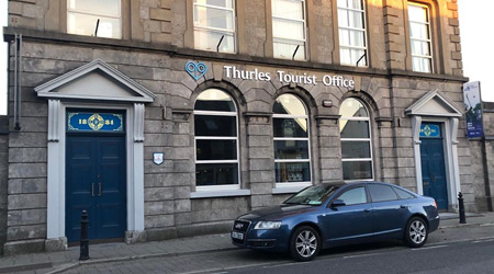
New Tourism Office: We now have a second new tourism office in Slievenamon Road, Thurles. We also have a new Thurles logo, “Halt Awhile”.
But, is this new Tourist Office in Thurles to be used to send our visitors to excellent attractions like Kilkenny castle; Trinity College Dublin; The Guinness Store House, Dublin; the Titanic Centre, Cobh, Co Cork etc. or are we going to try to develop already existing historical attractions within our own town and county?
Currently, all that exists in Thurles is what I call “Hobby Tourism“, with limited attractions unable to open on Saturdays or Sundays, or closed because a relative is “expecting a baby in July”. Indeed I led a walking tour group last year to a visitor centre here in the Thurles area, manned by a reluctant female guide who declared to the visiting group, “I hope ye won’t be long now, my mother is minding my baby”.
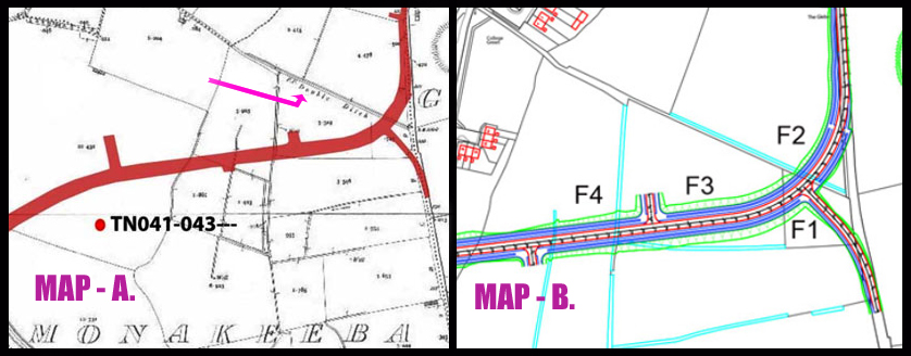
But enough of that; time to examine MAP-B shown above and contained in the Archaeological Impact Study on the inner relief road, undertaken by Mr Frank Coyne(BA MIAI, director of Aegis Archaeology), for client Mr Michael Devery, Road Design, (North Tipperary County Council, Civic Offices, Nenagh, Co. Tipperary.)
In MAP-B our interests are entirely focused on F1, F2, and F3(Shown above) described in the Archaeological Impact Study as quote: – “The subject site is a series of fields. For ease of reporting they were numbered in the direction in which they were walked, from east to west, and numbered F1 to F9.
Field 1 is a small field, covered in short grass and grazed by horses. Field 2 is a large open grassy field, covered in short grass and grazed by horses. Field 3 is a large open grassy field, covered in short grass and grazed by horses. It is very wet underfoot.
Spear Head & Sacrificial Axe Head. The afore mentioned Field 3, which is known as the “Well Field”, was where in 1996 the Monakeeba Bronze socketed spearhead was found, as stated in this same Impact Study.
The Monakeeba Bronze socketed spearhead together with the Monakeeba Stone Age Sacrificial Axe Head, latter found earlier, were both handed over to the National Museum by George Willoughby in 1996. [The Monakeeba Bronze socketed spearhead gets a mention in the Archaeological Impact Study, but for some reason the Stone Age Sacrificial Axe Head found on the Double Ditch was left out].
Please examine the fields again on the above map.
Field (1) bordering the south side of the Famine Double Ditch is small, containing a mere .745 acres. No photograph is taken to provide south to north landscape features, which incorporates the raised Double Ditch. Field (2) bordering the north side of the Famine Double Ditch contains 4.478 acres. No photograph identifies the raised Double Ditch. Field (3) Which contains 3.319 acres, “The Well field”; again no photograph taken to provided south to north landscape, which would incorporate the physical feature of this raised Double Ditch.
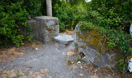
All photographs contained in the study were taken from an east to west prospective, so how did the road entrance to the ‘Double Ditch’ shown hereunder, sandwiched between field 1 and field 2 go unnoticed by Mr Coyne and remain unseen, even on road photographs provided in this same Archaeological Impact Study.
The Mill Road, Thurles looking west on the roadside entrance to the Double Ditch. Question; how despite being only 5ft (1.5 metres across) did this entrance, sandwiched between field 1 and field 2, get mysteriously ignored by Aegis Archaeology
Now go back to MAP-A above, again used in the survey and note the cartographers Ref. ‘F.P.Double Ditch‘. Then understand that the same Archaeological Impact Study contains an ‘Aerial View Image’ of that site, showing clearly the ‘Double Ditch’ using the website https://www.bing.com/
Again, as with MAP-A, while the ‘Double Ditch’ is clearly visible (both on the map and the ‘Aerial view Image’), its existence on the landscape has been totally disregarded by the ArchaeologicalImpact Study. Mr Coyne should now be recalled to re-examine his Impact Study.
Silence from Councillors, Politicians and Council Officials.
One thing has been learned from all of this; none of our elected representatives, sad to say, have any interest in promoting Mid-Tipperary tourism, except in the glossy brochures produced every 5 years, one month prior to General Elections or indeed Local Elections.
The now long forgotten Tipperary half promoted marketing ploywhich yielded nothing! Pictured some years ago: (Left)Siobhan Ambrose[Former Council Chairperson FF]; (Centre)FormerEnterpriseMinisterMary Mitchell O’Connor (FG) and (Right)Mr Joe MacGrath[Current CE, Tipperary Co. Co.]
When I set out initially to explore what, if any, new impact developments in our town of Thurles could have upon aspects of our rich history, it was never my intention to anger any individual.
My aim was to ask three questions to reassure both myself and others that valuable aspects of our town’s heritage where not placed in danger of being lost or destroyed.
Two of my three questions were eventually and reluctantly answered. My third question, which related to the possible destruction of the ‘Double Ditch’, was not answered, despite repeated enquiries.
The closest thing to an answer came in the form of an official communication (aforementioned) that clearly skirted around the issue, by essentially stating that there was no record of the “Double Ditch” that I referred to in my question. The implication being that if there was no record, then there was no issue.
This reply, in combination with the ongoing silence from Councillors, politicians and officials on the matter, has done little to reassure myself and the Thurles electorate, that the Double Ditch will remain safe from total destruction.
Finally, it is my strong belief that Tipperary County Council, still intend to totally destroy this piece of valuable history, without the consent of the people of Thurles, thus depriving them of their heritage and a major future tourist attraction.
To be continued.
Part 3 of “Tipperary Co. Co. Intent On Destroying Thurles Heritage” will be published in the coming days.


Recent Comments