The Thurles Town Car Park, running parallel with Thurles Children’s Playground, Thurles Leisure Centre and Swimming pool, Thurles Library and Thurles Theatre, has now been closed to all motor vehicles.
This new Town Park car park, which was only upgraded and officially opened less than 8 years ago, is now once again to undergo a major upheaval. The new project is expected to make this area unavailable for public use for possibly the next 16 months, at a cost of €3.4 million in Rural Regeneration Funding, with little or no discussion or consultation entered into, with town residents or the local business community.
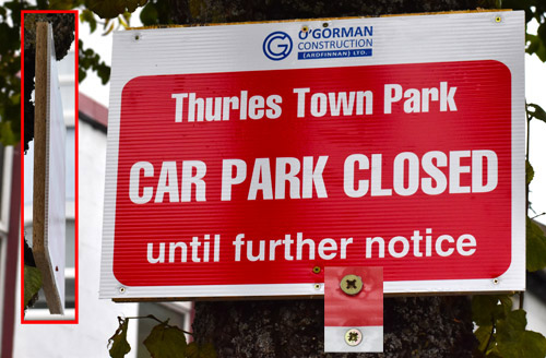
Sign attached on wooden background using possibly 2.5in cross head wood screws, fixed to a mature tree. Pic: G. Willoughby.
One of the signs indicating the car park closure is again screwed to a mature tree. We learned recently that earlier this year, Tipperary County Council hired a biodiversity officer, with a climate change officer already in place. At last month’s Thurles-Templemore District meeting, the District Engineer Mr Thomas Duffy and District Administrator Ms Sharon Scully said that from next year, there would be a proper biodiversity plan, so obviously no officials within Thurles Municipal District Council are in a position to request the contractor or other individual responsible, to remove the above sign until next year.
New Café.
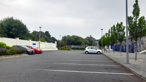
Thurles Town’s 49 Space Car Park Now Closed. Pic: G. Willoughby.
Thurles Farmers Market, following their July 2nd meeting, have learned that the stone agricultural sheds first erected during the Great Famine years, are to be refurbished and expanded by means of a glazed extension. When completed same is expected to accommodate an 83 seater Café, for which an operator has yet to be located as a tenant. Same café will exist just some 100 metres away from yet another café style restaurant, run by Tipperary Co. Council, which remains closed, after several tenants vacated the space, same unable get a fair return on their initial investment. So we now will have two Café’s existing side by side, erected and paid for by taxpayers, for the financial benefit of Tipperary Co. Council; with both Café’s competing with other similar private rate paying businesses each struggling close-by.
New Market Quarter: This new now planned ‘Market Quarter’ will see a canopy erected over a section of this car park area, which will be modified to allow access to water and electricity at a number of service points, for future market days. The restructured area is expected to lose 16 car parking spaces, to already struggling businesses in the immediate area. The canopy, which will be cream in colour with no branding, cannot come lower than 4m from the ground due to the fact that cars are being parked under the canopy. The council says no trader or customer parking will be allowed under the canopy during Market events.
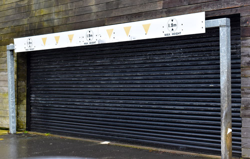
“The Source” Car Park, closed in 2020 continues to remain closed today (August 8th 2024). Pic: G. Willoughby.
“The Source” Car Park, funded through Rates paid by local business, has remained closed, since March 2020, due to malicious damage; today shows no visible effort being made to provide the much reduced and badly needed parking spaces, removed from Liberty Square, during Phase 1 of its upgrade.
A planning application by Tipperary County Council to install a footpath on the outskirts of Thurles, at Mill Road (formerly Manor Mill Road) was published last week.
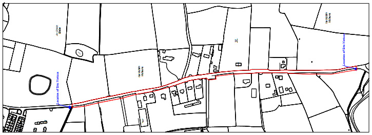
Map of Proposed Footpath For Mill Road, Thurles, Co. Tipperary.
The footpath, according to these overdue published plans, will stretch over a distance of some 950 meters in length (3117.0 ft or 0.6 of a mile) with a width throughout of 1.8 meters (almost 6ft), linking from the end of the existing broken path, almost to the stone bridge crossing the Drish River close to Lady’s Well.
The planning application notes that the Mill Road is a narrow, winding, local road connecting both the N75 (If travelling northwards) and the N62 (If travelling southwards) and has more recently come into huge use particularly by heavy goods vehicle (HGV’s), in their attempt to speed-up their access to other national routes, thus avoiding the bottleneck that has totally destroyed the business centre of Thurles Town .
The planning application now published, for this narrow stretch of the Mill Road, (affectionately known to locals as ‘Fat Arse Boulevard’), is necessary so as to provide a safe walking area for pedestrians and those intent on partaking of physical exercise.
The plans for this footpath project are indeed to be welcomed and are now on display until August 23rd next at the Council offices at Mathew Avenue, Thurles, and indeed also available online HERE.
Nota Bene: When you do go online HERE, to examine these plans, scroll down to “Report of Particulars of Proposed Development.pdf” and click on download.
NextSee Site Description:“The Mill road connects the N75 to the north and the N62 via Archerstown to the south. While this is a local road it also serves as a ‘rat run’ for vehicles avoiding Thurles town, seeking to access the national routes and also access the N62 north of Thurles …….”.
Using their words above; here, in this above statement, is full acknowledged admission by Council officials; (namely Mr Thomas Duffy [Checker] and Ms Sharon Scully [Approver]), that Thurles town centre has been destroyed, from the point of view of the operation of local businesses, with major traffic now avoiding the Liberty Square area.
Then, before you, our readers, let out a high pitched maniacal cry; comes sadly, an even greater admission. Quote, “There are a number of housing estates located on the N75 side of the L-4001 Mill Road, which are served by a roadside pedestrian footpath (500m) and also a paved, pedestrian, walking route along ahistorical walking path (‘double ditch’), located some 500m off the N75. Extension of the existing footpath from the‘Double Ditch’access, extending to the Drish Bridge for approx. 950m.“
As our readers will be aware, this historical walking path (‘double ditch’), now menctioned twice in this application, according to local councillors and their officials, did not formerly exist previously and was conveniently never included in the Archaeological Impact Statement by F. Coyne BA MIAI, which was commissioned and paid for by Tipperary Co. Council, courtesy of Tipperary rate payer funding.
No, it is not a paved pedestrian walking route, it is now a route which was completely levelled and received only a temporary coating of tarmacadam. Sadly, today an area critical in the attraction of Tourism to Thurles, no longer exists, courtesy mainly of former FF councillor Mr Seamus Hanafin and his other council colleagues, following the decision to build a useless ‘Inner Relief Road‘ through this historic area, when, if ever, eventual funding can be found. Of course there is no reference to this ‘Inner Relief Road’, mentioned in this planning application.
It should also be noted: The council, in principal only, recently agree a price for the purchase of land west of this Mill Road, with which to deliver the aforementioned ‘Inner Relief Road’, and the late delivery of plans for this new footpath, is understood to have been now an agreed component of this same land deal where space for the footpath had been earlier refused, and which contrary to commitments given by TD Mr Jackie Cahill in a press release, (dated back in October 4th 2021), the project has not yet received government funding.
Meanwhile: Submissions to the proposed development can be made free of charge until 4:30pm on Friday August 6th.
To quote the words contained in Sir Walter Scott’s epic poem, Marmion: A Tale of Flodden Field :- “Oh what a tangled web we weave, when first we practice to deceive.”
According to the Irish Nurses and Midwives Organisation (INMO), over 9,437 patients, including 70 children were admitted to our Irish hospitals, without a bed, during this past month (June 2024).
Reception Area University Hospital Limerick. Pic: G. Willoughby
This figure represents a 14% increase when compared to June 2023.
The hospital with the highest number of patients was University Hospital Limerick, latter serving North Tipperary with 1666 patients without a bed, in June.
University Hospital Galway had 1051 patients on trolleys this month, with 824 patients in Cork University Hospital also without a bed during the same period.
The figures remain as clear evidence as if same was required, that our health service remains far too reliant on a hospital system that does not have the sufficient bed capacity for an ever increasing Irish population.
Tipperary is marginally below the national average level of affluence, according to the 2022 Pobal HP Deprivation (Poverty) Index.
The Index, which is Ireland’s primary social gradient tool, found a nationwide improvement in measures such as employment and population growth, with levels largely returning to those observed in 2006, however persistent disadvantage remains for many communities.
Since the 2016 general election, County Tipperary has been a parliamentary 5 seater constituency that has elected to Dáil Éireann, 5 TDs, (Teachtaí Dála). In August last, 2023, an Electoral Commission, because of population increase, has recommended that Tipperary revert to a 2 x 3 seater constituency (6 TD’S), representing North and South Tipperary, in the next general election; same expected to take place at the latest in 2025, if not sooner.
Those 5 TD’S elected in the previous 2020 General Election, together with their vote counts are shown in the table hereunder.
The Pobal HP Deprivation Index uses data from Census 2022, analysing ten measures of an area’s levels of disadvantage. These include educational attainment, employment status and the numbers living in individual households. Almost 19,000 small areas, including 640 in Tipperary, (50-200 households) were indexed, leading to the development of a detailed map of the relative affluence and disadvantage.
Ms Anna Shakespeare(CEO of Pobal) has recently stated “The 2022 Pobal HP Deprivation Index is created to inform national policy and ensure that resources can be properly directed to where they are most needed. There has been an overall improvement for the majority of communities in Ireland, however we must also recognise that this is not being experienced equally. At Pobal, we are committed to working on behalf of government to support communities to combat disadvantage. This tool helps to create an understanding of the challenge of disadvantage and where it is prevalent, which is an important step towards achieving social inclusion for all.”
The 2022 Pobal HP Deprivation Index, is available on Pobal Maps HERE, (latter a free online Geographical Information System map viewer), which outlines the deprivation score for various geographic units such as county, constituency, electoral division or small area. Percentage data for the area is provided under a range of categories such as unemployment, educational attainment, and population change. The data can also be extracted for further analysis, through the geoprofiling viewer and compared between the 2022 Index Census and the three previous editions.
The two questions which now must be asked are:-
Why has Tipperary, with 5 Teachtaí Dála, been allowed to fall behind on the Pobal HP Deprivation Index?
Should the Tipperary electorate now change their choice of candidates, when it comes to voting in the 2025 General election?
It has become perfectly obvious that urban city planning ideas are now being mandatory enforced on rural, agricultural towns like Thurles, Co. Tipperary with disastrous consequences, forcing trading retail businesses to either close or fold their tents to move elsewhere.
Anyone who visited Dublin City recently will know that only public transport, cyclists and pedestrians can now get into and around its increasingly menacing streets, with any degree of efficiently.
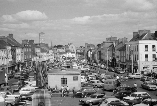
The busy prosperous Liberty Square of the 1960’s.
That is all well and good in Dublin with its network of buses, trams and taxis. Here in rural Thurles such public transport is very limited. There isn’t a Dart tram line to be found running from rural Upperchurch or indeed Two-mile-Borris or Littleton villages every 15 minutes. Indeed there is not one single bus shelter to be found in Thurles, to protect a prospective bus passenger from our inclement weather.
For those who wish to view what exactly will be forced on the residents and businesses of this once prosperous midland town, take a look here: N62-Slievenamon-Road-Phase-2.pdf
NOTE Page 6 of the above pdf: “Some of the key interventions that this strategy will deliver include significant investment in the provision of safe, segregated infrastructure to protect those walking and cycling on our roads, and initiatives to promote modal shift from motor vehicle travel to support environmental, safety and health objectives.”
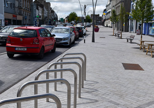
The picturesque Liberty Square, midday in 2023, asks a Question: Where are the town centre consumers; where are the cyclists; the walker, and the vehicle parking spaces. Answer: Driven out with the businesses. Gone to support German international discount retailers on the outskirts of Thurles, who offer very little local employment, while selling a considerable amount of German processed produce.
See also what is planned in the Draft Discussion maps for Slievenamon Road, shown here: N62-Slievenamon-Road-Map.pdf.
Question: Where are the Cycle Paths either on a half upgraded Liberty Square, town centre or on this newly designed, still to be revamped, Slievenamon Road plan? Answer: Non existent.
This October 2022 plan will most certainly drive home that final nail in our town centre’s coffin. However, the local electorate, (now remaining surprisingly silent), can express their anger, during local elections, expected to be held possible next March.


Recent Comments