The Unanswered Question: “Will the planned Thurles inner relief road impinge, in a negative way, on the 1846 Thurles “Double Ditch”, which has been a right of way and a Mass Path for almost 175 years and which is the property of the people of Thurles and a national monument?
The Double Ditch Exists
My articles over the last number of weeks have tried to erase any doubt as to the actual existence of a ‘Double Ditch’, at Mill Road, Thurles, Co. Tipperary; thus correcting the nonsense statement by Ms Janice Gardiner (Acting District Manager, Thurles, Municipal District) that, quote, “Tipperary County Council has reviewed all documentation relating to the planning aspects of the Thurles Inner Relief Road Project and can find no reference to the existence of the feature/path/monument you describe.”
It is my firm belief that no review ever took place and this reply, in combination with the ongoing silence from elected Councillors, elected Tipperary Politicians and Council Officials on the matter, has done little to reassure myself and others who care about our town that the “Double Ditch” is safe from destruction. Surely it is reasonable to assume that if the answer to the question asked is not NO, then it must be YES?
Furthermore, same previous articles published were and continue to be aimed solely at sounding alarm bells, ensuring that a piece of our rich Thurles heritage is not placed under serious threat; brought about through either genuine ignorance; wanton deliberate destruction; conplacency or greed, by TD’s we elected to protect our interests, namely Mr Jackie Cahill and Mr Michael Lowry.
The maps, aerial and ground videos, together with primary sources, which I have published and shared, following detailed research regarding this famine period, prove beyond doubt, the very existence of this “Double Ditch”, together with its origins and its massive historical significance.
To this end it must now be developed as an attraction, for what it is currently and for what it can be into the future; to the benefit of the local business community, through correctly marketed tourism and job creation.
New Tourism Office:
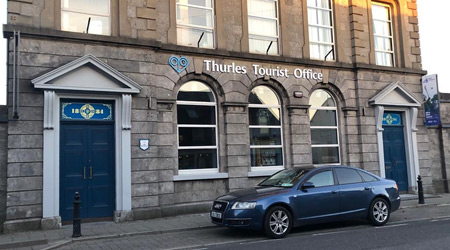
We now have a second new tourism office in Slievenamon Road, Thurles. We also have a new Thurles logo, “Halt Awhile”.

But, is this new Tourist Office in Thurles to be used to send our visitors to excellent attractions like Kilkenny castle; Trinity College Dublin; The Guinness Store House, Dublin; the Titanic Centre, Cobh, Co Cork etc. or are we going to try to develop already existing historical attractions within our own town and county?
Currently, all that exists in Thurles is what I call “Hobby Tourism“, with limited attractions unable to open on Saturdays or Sundays, or closed because a relative is “expecting a baby in July”.
Indeed I led a walking tour group last year to a visitor centre here in the Thurles area, manned by a reluctant female guide who declared to the visiting group, “I hope ye won’t be long now, my mother is minding my baby”.

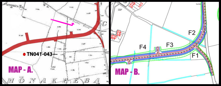
But enough of that; time to examine MAP-B shown above and contained in the Archaeological Impact Study on the inner relief road, undertaken by Mr Frank Coyne (BA MIAI, director of Aegis Archaeology), for client Mr Michael Devery, Road Design, (North Tipperary County Council, Civic Offices, Nenagh, Co. Tipperary.)
In MAP-B our interests are entirely focused on F1, F2, and F3 (Shown above) described in the Archaeological Impact Study as quote: – “The subject site is a series of fields. For ease of reporting they were numbered in the direction in which they were walked, from east to west, and numbered F1 to F9.
Field 1 is a small field, covered in short grass and grazed by horses.
Field 2 is a large open grassy field, covered in short grass and grazed by horses.
Field 3 is a large open grassy field, covered in short grass and grazed by horses. It is very wet underfoot.
Spear Head & Sacrificial Axe Head.
The afore mentioned Field 3, which is known as the “Well Field”, was where in 1996 the Monakeeba Bronze socketed spearhead was found, as stated in this same Impact Study.
The Monakeeba Bronze socketed spearhead together with the Monakeeba Stone Age Sacrificial Axe Head, latter found earlier, were both handed over to the National Museum by George Willoughby in 1996.
[The Monakeeba Bronze socketed spearhead gets a mention in the Archaeological Impact Study, but for some reason the Stone Age Sacrificial Axe Head found on the Double Ditch was left out].
Please examine the fields again on the above map.
Field (1) bordering the south side of the Famine Double Ditch is small, containing a mere .745 acres. No photograph is taken to provide south to north landscape features, which incorporates the raised Double Ditch.
Field (2) bordering the north side of the Famine Double Ditch contains 4.478 acres. No photograph identifies the raised Double Ditch.
Field (3) Which contains 3.319 acres, “The Well field”; again no photograph taken to provided south to north landscape, which would incorporate the physical feature of this raised Double Ditch.
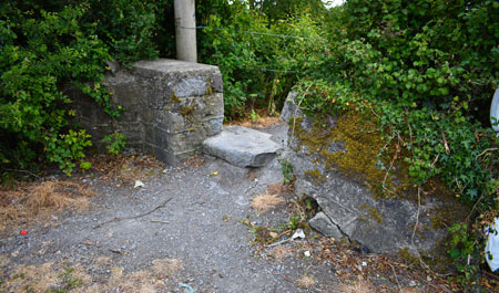
All photographs contained in the study were taken from an east to west prospective, so how did the road entrance to the ‘Double Ditch’ shown hereunder, sandwiched between field 1 and field 2 go unnoticed by Mr Coyne and remain unseen, even on road photographs provided in this same Archaeological Impact Study.

Now go back to MAP-A above, again used in the survey and note the cartographers Ref. ‘F.P. Double Ditch‘. Then understand that the same Archaeological Impact Study contains an ‘Aerial View Image’ of that site, showing clearly the ‘Double Ditch’ using the website https://www.bing.com/
Again, as with MAP-A, while the ‘Double Ditch’ is clearly visible (both on the map and the ‘Aerial view Image’), its existence on the landscape has been totally disregarded by the Archaeological Impact Study. Mr Coyne should now be recalled to re-examine his Impact Study.
Silence from Councillors, Politicians and Council Officials.
One thing has been learned from all of this; none of our elected representatives, sad to say, have any interest in promoting Mid-Tipperary tourism, except in the glossy brochures produced every 5 years, one month prior to General Elections or indeed Local Elections.

Pictured some years ago: (Left) Siobhan Ambrose [Former Council Chairperson FF]; (Centre) Former Enterprise Minister Mary Mitchell O’Connor (FG) and (Right) Mr Joe MacGrath [Current CE, Tipperary Co. Co.]
When I set out initially to explore what, if any, new impact developments in our town of Thurles could have upon aspects of our rich history, it was never my intention to anger any individual.
My aim was to ask three questions to reassure both myself and others that valuable aspects of our town’s heritage where not placed in danger of being lost or destroyed.
Two of my three questions were eventually and reluctantly answered. My third question, which related to the possible destruction of the ‘Double Ditch’, was not answered, despite repeated enquiries.
The closest thing to an answer came in the form of an official communication (aforementioned) that clearly skirted around the issue, by essentially stating that there was no record of the “Double Ditch” that I referred to in my question. The implication being that if there was no record, then there was no issue.
This reply, in combination with the ongoing silence from Councillors, politicians and officials on the matter, has done little to reassure myself and the Thurles electorate, that the Double Ditch will remain safe from total destruction.
Finally, it is my strong belief that Tipperary County Council, still intend to totally destroy this piece of valuable history, without the consent of the people of Thurles, thus depriving them of their heritage and a major future tourist attraction.
To be continued.
Part 3 of “Tipperary Co. Co. Intent On Destroying Thurles Heritage” will be published in the coming days.

I wouldn’t be surprised if they ignored it, corruption in terms of caring for historical environments seems to happen alot. The O’Rahilly house being destroyed and the ignorance in regards to this site just shows our officials only care about money at what will make them look good.