A planning application by Tipperary County Council to install a footpath on the outskirts of Thurles, at Mill Road (formerly Manor Mill Road) was published last week.
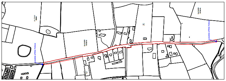
The footpath, according to these overdue published plans, will stretch over a distance of some 950 meters in length (3117.0 ft or 0.6 of a mile) with a width throughout of 1.8 meters (almost 6ft), linking from the end of the existing broken path, almost to the stone bridge crossing the Drish River close to Lady’s Well.
The planning application notes that the Mill Road is a narrow, winding, local road connecting both the N75 (If travelling northwards) and the N62 (If travelling southwards) and has more recently come into huge use particularly by heavy goods vehicle (HGV’s), in their attempt to speed-up their access to other national routes, thus avoiding the bottleneck that has totally destroyed the business centre of Thurles Town .
The planning application now published, for this narrow stretch of the Mill Road, (affectionately known to locals as ‘Fat Arse Boulevard’), is necessary so as to provide a safe walking area for pedestrians and those intent on partaking of physical exercise.
The plans for this footpath project are indeed to be welcomed and are now on display until August 23rd next at the Council offices at Mathew Avenue, Thurles, and indeed also available online HERE.
Nota Bene: When you do go online HERE, to examine these plans, scroll down to “Report of Particulars of Proposed Development.pdf” and click on download.
Next See Site Description: “The Mill road connects the N75 to the north and the N62 via Archerstown to the south. While this is a local road it also serves as a ‘rat run’ for vehicles avoiding Thurles town, seeking to access the national routes and also access the N62 north of Thurles …….”.Using their words above; here, in this above statement, is full acknowledged admission by Council officials; (namely Mr Thomas Duffy [Checker] and Ms Sharon Scully [Approver]), that Thurles town centre has been destroyed, from the point of view of the operation of local businesses, with major traffic now avoiding the Liberty Square area.
Then, before you, our readers, let out a high pitched maniacal cry; comes sadly, an even greater admission.
Quote, “There are a number of housing estates located on the N75 side of the L-4001 Mill Road, which are served by a roadside pedestrian footpath (500m) and also a paved, pedestrian, walking route along a historical walking path (‘double ditch’), located some 500m off the N75. Extension of the existing footpath from the ‘Double Ditch’ access, extending to the Drish Bridge for approx. 950m.“As our readers will be aware, this historical walking path (‘double ditch’), now menctioned twice in this application, according to local councillors and their officials, did not formerly exist previously and was conveniently never included in the Archaeological Impact Statement by F. Coyne BA MIAI, which was commissioned and paid for by Tipperary Co. Council, courtesy of Tipperary rate payer funding.
No, it is not a paved pedestrian walking route, it is now a route which was completely levelled and received only a temporary coating of tarmacadam.
Sadly, today an area critical in the attraction of Tourism to Thurles, no longer exists, courtesy mainly of former FF councillor Mr Seamus Hanafin and his other council colleagues, following the decision to build a useless ‘Inner Relief Road‘ through this historic area, when, if ever, eventual funding can be found.
Of course there is no reference to this ‘Inner Relief Road’, mentioned in this planning application.
It should also be noted: The council, in principal only, recently agree a price for the purchase of land west of this Mill Road, with which to deliver the aforementioned ‘Inner Relief Road’, and the late delivery of plans for this new footpath, is understood to have been now an agreed component of this same land deal where space for the footpath had been earlier refused, and which contrary to commitments given by TD Mr Jackie Cahill in a press release, (dated back in October 4th 2021), the project has not yet received government funding.
Meanwhile: Submissions to the proposed development can be made free of charge until 4:30pm on Friday August 6th.
To quote the words contained in Sir Walter Scott’s epic poem, Marmion: A Tale of Flodden Field :-
“Oh what a tangled web we weave, when first we practice to deceive.”


Leave a Reply