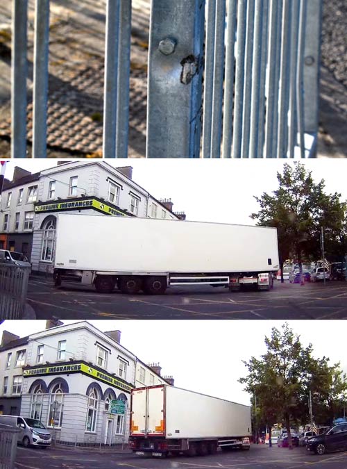
The improvements made to Liberty Square, Thurles, Co. Tipperary, under Phase 1 of its upgrade, are without doubt aesthetically pleasing, but same have failed to address the traffic congestion problems that currently plague this area.
These past improvements and the proposed developments now suggested, under Phase 2, still have not gotten to the root of Liberty Square’s real needs; amongst them the much sought after ‘Ring Road’ that would take excess traffic out of this area.
In the absence of a ring road, it remains very difficult to enjoy this superficial upgrade to Liberty Square, when the majority of us associate it with the most frustrating of daily traffic jams.
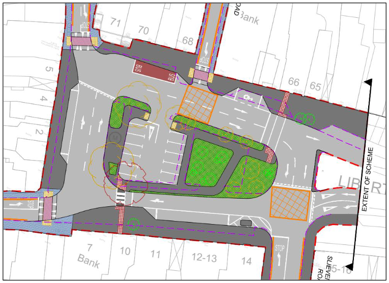
If Phase 2 is accepted, traffic will most certainly bring the centre of Thurles town to a standstill, with a single lane now being proposed at the junction of Slievenamon Road and Liberty Square, same coming into use, continuously, by heavy goods vehicles (HGV’s). {See layout plan hereunder}. So too, with
Overall we found this report to be both contradictory, misleading and containing what appears to be a paste & copy job; e.g. quotes:-
* * “The Thurles Liberty Square Phase 2 project will encourage compact growth by reducing congestion in the town centre and providing better pedestrian facilities, making Thurles a healthier and more liveable town.”
Congestion has greatly increased since Phase 1 was implemented, resulting in, according to businesses, a reduction of 60% in footfall. The nitrogen dioxide produced by vehicle exhaust fumes has increased creating symptoms that are similar to ozone and sulphur dioxide due to constant traffic delays. The report has failed to supply any details of current air quality and has not commented on the smell of hydrogen sulphide being emitted through drains in this area. The report fails to recognise that buses double park on the northwest of Liberty Square, reducing this area to one lane of traffic and continue to promote this idiotic notion, instead of moving same to install two bus parking spaces on the west side.
* * “The Thurles Liberty Square Phase 2 project provides better access to education services in
Thurles, through the widening of footpaths around the main square and through the provision of
a school zone.”
One primary school drop down and pick up area exists on Liberty Square; operating from the car park behind the former Ulster Bank building, resulting in same area becoming a no-go area between the hours 2:00pm and 4:00pm, to those wishing to go shopping within the town centre. The provision of a School Zone is not immediately evident.
* * “Explore opportunities to maximise physical activity and recreational amenities in the natural environment. By providing dedicated facilities for walking and cycling, the Thurles Liberty Square Phase 2 project aims to create opportunities for physical activity and exercise for residents and visitors alike.”
Where are the cycling lanes proposed? Over one year ago, Tipperary Co. Council removed the cycle lane previously provided on Clongower Road, same part of some €400,000 funding acquired by the said Council just 5 years ago. Dedicated facilities for walking on Liberty Square were always provided. Of the 19 Crome Bollard Bike Racks currently provided for use on Liberty Square, not one was found to be in use today.* * “Ensure that the planning, development and design of towns, cities and schools promotes cycling and
walking with the aim of delivering a network of cycle routes and footpaths.”
“The aim of the Department of Health’s National Physical Activity Plan is to increase physical activity levels across the whole population, and the Plan sets separate targets for adults, children and older people to reach the recommended levels of physical activity”.
Thurles town centre is a small rural town which required special planning, related directly to successful business and consumer satisfaction. People do not come into town centres to increase recommended levels of physical activity; for such, local residents use the Jimmy Doyle road etc.
View hereunder Tipperary Co. Council’s Part 8 Revised Planning Report, Phase2, latter updated in early July 2024, and prepared by AECOM.
Quoting from the AECOM report:
“The Liberty Square Phase 2 proposes the relocation of 12 car parking spaces from the central island car park. This is to be replaced to accommodate improved pedestrian crossing facilities across the square including upgraded controlled pedestrian crossings and a new footpath, with associated landscaping to improve public realm. Where possible this landscaping will include SuDS*, features such as rain-gardens.
There are pedestrian crossings proposed to connect the central parking island to the north and south sides of the Square.“
*[ SuDS – Sustainable Drainage or SuDS is a way of managing rainfall that minimises the negative impacts on the quantity and quality of run-off whilst maximising the benefits of amenity and biodiversity for people and the environment],
“The crossing on the northern side of the central parking island is to be a controlled crossing and the crossing on the southern side is proposed to be a zebra crossing. These crossing will include tactile paving for visually impaired users.”
“The parking in the central island is being removed to reduce the number of pedestrian crossings to the island. This will in turn reduce the probably of a potential collision involving a pedestrian crossing to or from the car park.”
“In addition to the changes to the central island the scheme includes the widening of footpaths at Liberty Square on the south, west and northern sides. To accommodate this widening and the proposed crossings, the parking on these sides of the Square is to be reduced. The carriageway is being reduced to provide more space for pedestrians to navigate around the Square and to provide adequate space for the pedestrian crossings.”
“On the northern side of the square the taxi rank is to be replaced with a disabled parking bay, and a formal bus stop is to be put in place.”
“On the western side of the square there is to be the reduction from 5 to 3 spaces.”
“The southern side of the square will see a reduction from 7 spaces, including 1 disabled bay, to 3 spaces. The southern side of Liberty Square is proposed to be reduced from two lanes to one; to accommodate the zebra crossing. {See layout plan above}.”

“Slievenamon Road: An existing pedestrian crossing is located along Slievenamon Road approximately 20m from its junction with Liberty Square. This crossing is to remain in place, together with the existing guardrails, that are currently in place on either side of the road.”
“There are proposed raised uncontrolled pedestrian crossings across the junctions of Liberty Square and
O’Donovan Rossa Street, Friar Street and Parnell Street. The crossings will include tactile paving for visually impaired pedestrians.”
END.
Tipperary County Council is required to make full plans and particulars of this proposed development available for inspection. Same will be made available at the Thurles Municipal District Office, Civic Offices, Castle Avenue, Thurles, Co. Tipperary, (E41 KA44).


Leave a Reply